 Great Lakes Coordinating Committee
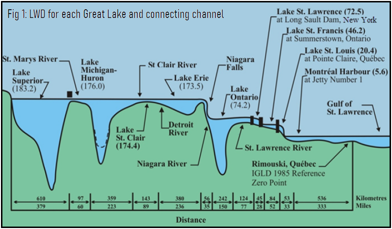
 Low Water Datum (LWD), or chart datum, is “a lake-wide surface so low that the water level will seldom fall below it.” In essence, it is the lowest water level that should be encountered the majority of the time. LWD represents the geopotential elevation for each of the Great Lakes, their connecting channels, and the St. Lawrence River system to which the depths shown on navigational charts and the authorized depths for navigation improvements are referred. LWD serves as the reference for navigational charts. In the Great Lakes, LWD also acts as the reference plane for authorizing harbor improvements.
History & Background
Low Water Datum (LWD) was established in 1933 using data from the 1800s. In Moore 1939, Datum Planes on the Great Lakes, common opinion desired the adoption of a single datum plane for each Great Lake. Decisions reached by lake were:
- For Lake Superior, the minimum state under regulation was chosen.
- For Lakes Michigan and Huron, the Standard Low Water used by the US Lake Survey was selected.
- For Lake Erie, a level between Standard Low Water and an improvement plane was selected.
- For Lake Ontario, LWD was fixed between Standard Low Water and an improvement plane.
Each of the Great Lakes LWD was defined relative to a specific bench mark at one station (on each lake), which was used to compute lake-wide average levels. As part of the IGLD (1955) and IGLD (1985) updates, LWD was updated to the new IGLD simply by shifting the LWD by the difference in IGLD dynamic heights in the master station. The historical record of water levels has not been reviewed in the context of LWD since their original determination in 1933.
Current Status of LWD
The Great Lakes may have changed enough over the past 100 years to warrant a reevaluation of Low Water Datum (LWD). These changes can be attributed to shifts in hydraulic and hydrologic conditions and large fluctuations in lake water levels, even across a few years. In recent years water levels have experienced historic lows on the lower lakes and highs on the upper lakes. This has led to washed out docks and has contributed to a feeling that the lake levels may now be too low or too high. Several controlling structures that now exist to divert water did not exist 100 years ago. We are seeing those effects.
What governs an Update to LWD?
There is little existing documentation and policy that governs Low Water Datum (LWD) updates, at least not in the Great Lakes. The Coordinating Committee on Great Lakes Basic Hydraulic and Hydrology Data is actively working to document its current actions as a way to help drive future recommendations for LWD in the Great Lakes.
Factsheets